Riparian Rights on Jupiter Island: Essentials for Buyers
December 18, 2025
December 18, 2025
Thinking about a waterfront home on Jupiter Island? The shoreline is a dream, but your rights on and over the water are detailed and regulated. If you know how riparian and littoral rights work in Florida, you can protect your view, your dock plans, and your long‑term property value. This guide breaks down the essentials so you can buy with clarity and confidence. Let’s dive in.
In Florida, riparian rights apply to properties along rivers and tidal waterways. Littoral rights apply to land that fronts the ocean or large lakes. On Jupiter Island, you may encounter both concepts depending on whether a parcel touches the Atlantic or the Intracoastal Waterway.
Private ownership typically runs to the mean high‑water line on tidal waters. Seaward of that line, the State of Florida generally holds title to sovereignty submerged lands for public trust uses like navigation and fishing. Private use of those submerged lands often requires state authorization.
Shorelines change over time. Gradual gains of land, known as accretion or reliction, usually become part of the property. Sudden changes from storms or channel shifts, called avulsion, are treated differently. When that happens, legal boundaries may not move with the sand, which is why surveys and legal reviews matter.
In this area, most shoreline work triggers multi‑agency review. Depending on your site, you may need approvals from the Town of Jupiter Island or Martin County for local building and zoning. The Florida Department of Environmental Protection often reviews projects that use sovereignty submerged lands or cross the Coastal Construction Control Line.
Projects in navigable waters and wetlands can also require federal authorization through the US Army Corps of Engineers. If protected species or sensitive habitat are present, the Florida Fish and Wildlife Conservation Commission or federal wildlife agencies may add conditions. Expect to provide a current survey showing the mean high‑water line, an engineered site plan, and any mitigation proposals if vegetation or seagrass could be affected.
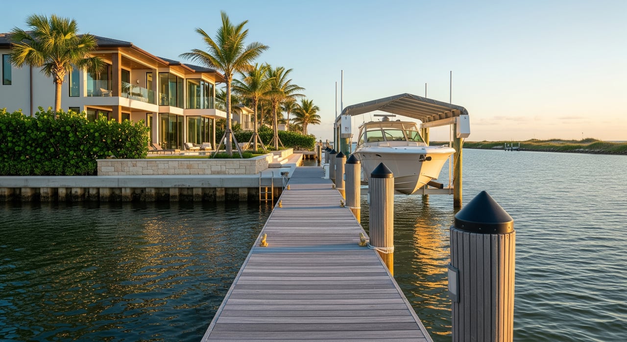
Local codes commonly require a dock to center on your frontage and respect side setbacks so neighbors maintain access. Agencies also limit how far a dock can extend into a channel to protect navigation and seagrass. Covered slips and boathouses may face additional restrictions or may not be allowed in certain zones.
Seawalls, bulkheads, and revetments typically require permits. Rebuilding or raising a seawall can trigger coastal controls, and any portion on or seaward of mean high water usually needs state authorization. Dredging for deeper access is often the most difficult approval to obtain, especially in seagrass or protected habitat.
Owners are usually responsible for maintenance, permit compliance, and liability for existing shoreline structures on their property. Budget for inspections, repairs after storms, and renewal of any expiring authorizations.
A clear water view today does not guarantee a clear view tomorrow. Florida law does not grant a universal private right to an unobstructed view. Preserved sightlines usually arise from recorded easements, HOA rules, or specific local approvals.
Vegetation along dunes and shorelines is protected in many cases. Mangrove trimming and removal are regulated and often require permits. On Atlantic‑facing parcels, the Coastal Construction Control Line adds design limits, and sea turtle nesting seasons often impose timing and lighting rules. If a property sits within protected habitat, expect additional conditions.
If the estate is part of a platted community or subject to HOA covenants, landscaping and view standards may apply. Always obtain and review recorded documents to confirm your rights and obligations.
Before you price in a dock, a boathouse, or a forever view, confirm the facts:
Title and recorded items
Survey and boundaries
Permits and as‑builts
Environmental and coastal constraints
Navigation and usage
Insurance and maintenance
Professional team
If you are evaluating a specific Jupiter Island parcel, start by requesting the seller’s complete file for shoreline work, including permits, maintenance records, and as‑built drawings. Order an ALTA‑level survey that clearly shows the mean high‑water line and all easements. Ask local permitting staff about the property’s history and likely requirements for new or replacement structures.
Then, have a coastal engineer outline dock feasibility, potential mitigation, and construction timelines, including any sea turtle nesting restrictions. Build these facts into your offer strategy and inspection period so you are protected if approvals prove more complex than expected.
When you want a clear path from offer to closing, work with an advisor who can navigate both the legal and the practical sides of Jupiter Island waterfront ownership. For discreet guidance and a plan tailored to your goals, connect with Debra P. Rochlin, PA.
Stay up to date on the latest real estate trends.


Lifestyle
A Coffee Lover's Guide to Jupiter's Finest Cafes

Real Estate
Exploring Home Warranty Options: A Guide for Florida Residents

Real Estate
Effortlessly Navigate Your Relocation with Proven Strategies